

New Delhi: A 7.4-magnitude earthquake struck western Colombia at 7:34 a.m. local time on Monday, August 10, 2026, causing extensive destruction across multiple provinces, killing more than 200 people according to the latest figures from local authorities, and leaving over 3,000 still missing. The tremor, centered near San Jose del Palmar in Choco province on the Pacific coast roughly 400 kilometers west of Bogota, was felt throughout much of the country and in neighboring Ecuador, Panama, and parts of Venezuela. President Abelardo de la Espriella, sworn into office only days earlier, declared a national state of emergency and directed all available government resources toward rescue and recovery operations.
The United States Geological Survey and Colombian geological agencies both confirmed the magnitude at 7.4. Early Colombian reports had listed a preliminary magnitude of 6.6 before the higher figure was verified. The epicenter was located approximately 5 kilometers east of San Jose del Palmar. Depth estimates ranged from about 79 kilometers according to Colombian authorities to around 107 kilometers according to the USGS. No tsunami threat was issued by the U.S. tsunami warning system. The intermediate depth limited some surface intensity relative to shallower events, yet the quake still produced strong shaking across nine departments and all 32 departmental capitals.
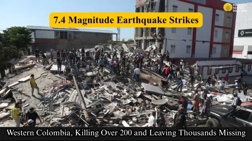
Rising Casualties and Severe Damage Across Western Cities
Casualty numbers rose steadily through the first 24 hours. Initial reports put the death toll at least at 69, including 18 fatalities in Pereira and two in Manizales. Updated figures later confirmed at least 111 dead and 87 injured. Subsequent tallies from local authorities pushed the confirmed death toll past 200, with more than 3,000 people still unaccounted for and feared trapped under collapsed structures. Officials warned that the final number was expected to increase as rescue teams gained access to more remote areas.
Risaralda province recorded the highest provincial toll, with Governor Juan Diego Patino reporting 42 deaths. Manizales Mayor Jorge Eduardo Rojas confirmed three people killed in his city. In Buenaventura, Colombia’s main Pacific port, one person died after a building collapse. Cali faced some of the most intense rescue challenges. Mayor Alejandro Eder reported that more than two dozen buildings had collapsed, at least 12 critical points required immediate attention, and people remained trapped. Two survivors—an elderly woman and a young girl—were pulled from the rubble in early operations. Nurses in Cali were seen moving hospital patients outside in their beds as a precaution.
Visual reports and local media accounts described buildings cracking and facades shearing away in San Jose del Palmar. Similar scenes appeared in the El Cable commercial district of Manizales, where streets filled with debris. One tower of a Gothic-style cathedral in Manizales was toppled. Cracks and structural failures were also documented in Cali, Armenia, Pereira, and Medellin. The mayor of Cali characterized the damage as major. In Bogota, residents fled into the streets in pajamas as emergency sirens sounded, though city officials reported no preliminary structural damage of significance. Medellin authorities likewise reported no initial injuries in Colombia’s second-largest city.
Choco Governor Nubia Carolina Cordoba-Curi confirmed a major earthquake in the province and voiced concern about possible aftershocks. While the epicenter was near San Jose del Palmar, injuries and significant building damage occurred in the provincial capital Quibdo. Authorities there began systematic damage assessments. The civil aviation authority suspended flights at airports in Pereira, Manizales, Quibdo, Armenia, Cartago, and Buenaventura pending infrastructure inspections.
Government Mobilizes Under New Leadership as Regional Tremors Felt
President Abelardo de la Espriella suspended planned activities and coordinated the national response from Bogota. In a national address he stated that the government had deployed all its capabilities to protect lives, assist affected communities, and deliver aid wherever needed. He identified the rescue of people still trapped under rubble as the immediate priority and announced he would personally supervise recovery efforts while establishing an emergency center in San Jose del Palmar. The right-wing politician, who had never previously held elected office, faced his administration’s first major crisis within days of taking the oath.
The earthquake was felt across the border in Venezuela, including in Tachira state and the city of Barquisimeto, according to witnesses. The timing revived memories of twin earthquakes measuring 7.2 and 7.5 that struck Venezuela in late June 2026. Those shallower events, occurring at depths of 10 to 22 kilometers, destroyed hundreds of buildings and killed more than 5,000 people, with some later accounts placing the toll above 6,000. The Colombian quake’s greater depth reduced its comparative surface impact, yet the regional psychological effect remained significant.
Colombia’s geography helps explain both the frequency of seismic activity and the pattern of damage. The country occupies northwestern South America and shares land borders with Panama, Venezuela, Brazil, Peru, and Ecuador. It is the only South American nation with coastlines on both the Caribbean Sea and the Pacific Ocean. The equator crosses its southern edge. The Colombian Andes divide into three cordilleras—Occidental, Central, and Oriental—creating steep terrain and intermontane valleys. The highest peak is Pico Cristóbal Colón. Major river systems include the Amazon, Orinoco, Putumayo, and Magdalena. This tectonic setting, where the Nazca and Caribbean plates interact with the South American plate, places large portions of the national territory in an active seismic zone.
Historical Precedents Underscore Ongoing Vulnerability
Earthquakes are relatively common in Colombia, yet secondary effects such as landslides have produced some of the country’s deadliest natural disasters. The 1985 Armero tragedy, triggered by the eruption of Nevado del Ruiz and resulting mudflows, killed approximately 25,000 people. In 1999 a 6.2-magnitude earthquake centered near Armenia and Pereira in the coffee-growing region claimed more than 1,000 lives and caused widespread destruction. The August 10, 2026 event ranks among the strongest to strike the country in recent decades.
Rescue teams from Bogota and Medellin reinforced local efforts in Cali and other hard-hit areas. Search operations continued among collapsed residential and commercial buildings. Provincial and municipal leaders repeatedly urged residents to remain alert for aftershocks while systematic damage assessments proceeded. As of the most recent official updates, search and rescue remained the overriding priority, infrastructure inspections continued, and casualty figures were described as fluid and expected to rise.
The disaster has tested the capacity of Colombia’s emergency systems and the responsiveness of a newly installed national administration. With more than 100 buildings reported collapsed in the most affected western cities and thousands still missing, the coming days will determine the full human and economic cost. Authorities continue to emphasize that the final accounting of lives lost and communities disrupted is not yet complete.
Frequently Asked Questions
What was the magnitude, location, and timing of the Colombia earthquake?
The earthquake registered a magnitude of 7.4 according to both the United States Geological Survey and Colombian geological authorities. It struck at 7:34 a.m. local time on Monday, August 10, 2026. The epicenter was located near San Jose del Palmar in Choco province on Colombia’s Pacific coast, approximately 5 kilometers east of the town and about 400 kilometers west of Bogota. Depth estimates ranged from around 79 kilometers (Colombian agencies) to approximately 107 kilometers (USGS). Early Colombian reports had listed a preliminary magnitude of 6.6 before the higher figure was confirmed.
How many people were killed and injured, and where were the highest casualties?
Initial reports put the death toll at least at 69, including 18 fatalities in Pereira and two in Manizales. Updated figures later confirmed at least 111 dead and 87 injured. Subsequent tallies from local authorities indicated the confirmed death toll had crossed 200, with more than 3,000 people still missing and feared trapped. Risaralda province recorded the highest provincial toll at 42 deaths. Manizales confirmed three fatalities, Buenaventura reported one death from a building collapse, and Cali faced multiple structural failures with people remaining trapped. Authorities warned the final number was expected to rise.
Which areas suffered the most damage and what kind of destruction occurred?
The heaviest damage was concentrated in western Colombia, particularly in Risaralda, Caldas, Valle del Cauca, and Choco departments. Cali reported more than two dozen collapsed buildings and at least 12 critical points requiring urgent attention. Manizales saw a tower of a Gothic-style cathedral toppled and significant debris in the El Cable commercial district. Cracks and facade failures were documented in Pereira, Armenia, Medellin, and Quibdo. Buildings cracked and people were seen stumbling in the streets of San Jose del Palmar. Bogota experienced strong shaking that sent residents into the streets, though officials reported no preliminary structural damage of note. Airports in Pereira, Manizales, Quibdo, Armenia, Cartago, and Buenaventura suspended flights pending inspections.
How did the Colombian government respond to the disaster?
President Abelardo de la Espriella, who had been sworn in only days earlier, declared a national state of emergency. He suspended planned activities, coordinated the response from Bogota, and stated that the national government had deployed all available resources to protect lives, assist affected communities, and deliver aid. He identified the rescue of people trapped under rubble as the first priority and announced he would personally supervise recovery efforts while establishing an emergency center in San Jose del Palmar. Additional disaster-response teams were requested from Bogota and Medellin to support operations in Cali and other hard-hit areas.
Was the earthquake felt outside Colombia, and how does it compare with recent regional events?
Yes. Tremors were felt in neighboring Ecuador and Panama, as well as in Venezuela’s Tachira state and the city of Barquisimeto. The event revived memories of the twin 7.2- and 7.5-magnitude earthquakes that struck Venezuela in late June 2026, which were shallower (depths of 10–22 kilometers) and killed more than 5,000 people. No tsunami threat was issued. Colombia’s location in a seismically active zone—where the Andes divide into three cordilleras and major tectonic plates interact—makes such events relatively common, though the August 10 quake ranks among the strongest to hit the country in recent decades.