

New Delhi: India’s southwest monsoon has intensified dramatically in early July 2026, triggering severe flooding, landslides, and infrastructure damage across multiple states. The India Meteorological Department (IMD) has issued multiple red alerts amid extremely heavy rainfall, with urban centers like Delhi, Surat, Mumbai, and others facing acute waterlogging and related disasters. This year’s monsoon has already claimed lives, displaced thousands, and disrupted daily life, highlighting the growing vulnerability of Indian cities to urban flooding driven by climate change, unplanned development, and inadequate infrastructure.
As of July 9, 2026, the monsoon has covered the entire country, albeit a day later than the typical July 8 date. This delay, however, has not diminished its ferocity. Heavy to extremely heavy rains have battered regions from the northern plains to the southern coasts, with cumulative rainfall in many areas exceeding normal levels and exacerbating long-standing urban flood risks.
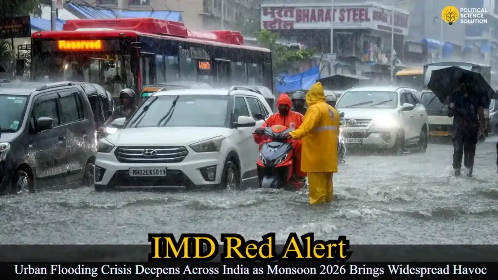
Understanding Urban Flooding: A Rising Threat in Indian Cities
Urban flooding occurs when excessive rainwater runoff overwhelms drainage systems in built-up areas, leading to temporary inundation of roads, homes, and public spaces. Unlike rural flooding, which often involves river overflows over larger areas, urban flooding is intensified by human activities. According to insights from the National Disaster Management Authority (NDMA), urbanization can amplify flood peaks by 1.8 to 8 times and increase flood volumes by up to 6 times due to the proliferation of concrete surfaces that prevent water absorption.
The impacts are multifaceted and devastating. Residents face displacement, loss of life and property, and damage to critical infrastructure such as power grids and water supply networks. Public health risks surge with water-borne diseases spreading through contaminated floodwaters, while environmental degradation pollutes rivers, lakes, and other water bodies. In 2026, these effects are playing out in real time across major cities.
Key causes include extreme rainfall events linked to climate change, such as cloudbursts and erratic monsoon patterns seen in past events like the 2005 Mumbai deluge. Unplanned urbanization has replaced permeable soil with impervious concrete, drastically reducing natural infiltration. Encroachments on lakes, wetlands, floodplains, and stormwater drains have worsened the problem—Bengaluru, for instance, has reportedly lost 65 lakes over the past two decades. Inadequate and poorly maintained drainage systems, often clogged by solid waste, fail during downpours. Additionally, poor water management practices, including sudden dam releases, contributed to disasters like the 2015 Chennai floods from the Chembarambakkam reservoir.
Monsoon Mayhem: State-by-State Impact on July 8-9, 2026
The heaviest impacts have been felt in northern and western India. In Delhi, overnight rains on July 8-9 led to widespread waterlogging, uprooted trees, and traffic chaos. The IMD issued a red alert for the capital, with Safdarjung recording 72.6 mm of rainfall in 24 hours ending at 8:30 a.m. on July 9. Tukhmirpur in northeast Delhi saw the highest at 160 mm. Areas like Jangpura underpass, Geeta Colony, Vikas Marg, Munirka, Sadar Bazar, Dwarka, East Delhi, and New Delhi Railway Station were severely affected. Delhi Fire Service responded to multiple tree falls, including two on Raja Dhir Singh Marg near ISKCON temple and National Heart Institute, and others on Guru Ravidas Marg and Dhingra Marg. A parked car was damaged in Ranjeet Nagar, though no injuries were reported.
Chief Minister Rekha Gupta and PWD Minister Parvesh Sahib Singh personally inspected sites, directing dewatering efforts. Preemptive desilting in drains like Narela and Dwarka helped limit damage compared to previous years, but challenges persisted. Schools in parts of the NCR were closed, and traffic police managed snarls on the Delhi-Noida Expressway.
Surat in Gujarat recorded 17 rain-related deaths, with over 3,600 people rescued and 4,300 shifted from low-lying areas. Chief Minister Bhupendra Patel announced ₹500 crore for long-term anti-flooding measures, acknowledging the recurring nature of the crisis. Floodwaters are receding, allowing gradual return to normalcy.
Mumbai and Maharashtra saw significant disruption. The BMC reported 1,711 tree and branch fall incidents since July 1, 2026—up sharply from 855 in 2025. In Raigad’s Khalapur, around 3,000 HPCL gas cylinders were swept into the Patalganga River. Thane district reported three deaths, 800 evacuations, and two lightning injuries. IMD forecasts for Mumbai included cloudy skies with intermittent light to moderate rain, heavy spells possible, and gusty winds up to 40-50 kmph. Red alerts were issued for Mumbai, Palghar, Thane, and Raigad earlier in the week.
In Uttar Pradesh, red alerts covered western parts, with heavy to extremely heavy rain causing five deaths: two women from lightning in Sant Kabir Nagar, a 14-year-old boy in Kushinagar, and two from a wall collapse in Bulandshahr’s Mundakheda village.
Uttarakhand placed seven districts, including Dehradun, under red alert. Landslides and rising river levels disrupted traffic on 107 routes. Schools closed in four districts. Heavy rainfall affected both Garhwal and Kumaon regions.
Himachal Pradesh’s Kinnaur district witnessed flash floods submerging a 100-foot iron bridge in Lippa village, isolating the area and endangering nearby houses. The Shimla Met Office issued a yellow alert until July 15.
Rajasthan experienced extremely heavy rain in Kota and Bharatpur divisions, with Badesar, Nimbahera, and Bayana recording 9 cm. Forecasts predicted continued activity in Bharatpur on July 10.
Arunachal Pradesh reported fresh floods and landslides damaging houses, roads, and crops in six districts. Orange alerts were active, with easing expected from July 10.
Kerala continued under heavy rain, with orange alerts in Malappuram, Kozhikode, and Wayanad, and yellow alerts elsewhere. Wayanad declared holidays for educational institutions. A boat capsized near Goa’s Morjim beach, rescuing three fishermen amid rough seas.
Noida and Ghaziabad saw road collapses, with a car and scooter falling into a pit in Ghaziabad’s Vasundhara Sector 13. Government schools were closed.
Other incidents included public access bans at Madikeri’s Raja’s Seat in Karnataka due to landslides, and ongoing alerts in Odisha, Jharkhand, Bihar, West Bengal, Northeast states, and southern regions.
Broader monsoon dynamics involve a well-marked low-pressure area over the northwest Bay of Bengal, the seasonal trough, an offshore trough along the west coast, and a western disturbance. These systems are fueling widespread rain, thunderstorms, lightning, and gusty winds. July rainfall is forecasted below normal overall, despite recent intense spells. Delhi-NCR expects more rain till July 10-11, with drier conditions later.
Government and Administrative Response
Authorities across states have activated emergency operations. Dewatering pumps, desilting drives, and coordination between agencies are underway. In Delhi, the government emphasized readiness with full departmental mobilization. Surat’s substantial funding announcement signals a shift toward permanent solutions. Fishermen advisories are in place for rough seas, and people in low-lying, hilly, and landslide-prone areas are urged to stay vigilant, avoid water bodies, and follow IMD updates.
Air quality in Delhi surprisingly remained satisfactory at AQI 61 despite the rains, offering some environmental relief.
Long-Term Solutions: The Path Forward for Urban Flood Resilience
Addressing urban flooding requires a multi-pronged strategy. Data-driven approaches are essential: expanding Doppler radars, automatic rain gauges, and real-time monitoring, alongside GIS-based contour maps, drainage inventories, and flood-hazard zoning.
Infrastructure upgrades must blend grey and green solutions. Modernizing stormwater drains, regular desilting, and removing encroachments are priorities. Nature-based solutions inspired by China’s “Sponge City” model—permeable pavements, green roofs, rain gardens, and watershed planning—can enhance absorption and reuse of runoff.
Institutional strengthening involves dedicated urban flood management cells, localized disaster plans, inter-agency coordination, and community participation through urban local bodies. Farmers are advised to monitor kharif crops, ensure drainage, and adopt resilient varieties like short-duration pulses and oilseeds amid waterlogging risks.
Conclusion: Building Resilience Amid Monsoon Challenges
The 2026 monsoon has once again exposed the fragility of India’s urban landscape to extreme weather. While immediate relief efforts are critical, the recurring pattern of floods demands sustained investment in sustainable urban planning, early warning systems, and ecosystem restoration. As climate patterns evolve, proactive governance and public awareness will be key to minimizing future losses.
Citizens are encouraged to heed weather advisories, support local conservation efforts, and advocate for smarter infrastructure. With the monsoon expected to remain active in coming days, staying informed through official channels remains paramount for safety across the nation.
FAQs
1. What is urban flooding and why has it become more severe in Indian cities like Delhi and Surat in 2026?
Urban flooding is the inundation of land or property in cities caused by heavy rainfall overwhelming drainage systems. In 2026, it has intensified due to extreme monsoon rains, rapid concretization reducing water absorption, encroachment on water bodies and drains, and poor maintenance of stormwater infrastructure. Events in Delhi (160 mm in Tukhmirpur), Surat (17 deaths), and other cities show how unplanned urbanization amplifies runoff, leading to waterlogging, infrastructure damage, and health risks.
2. What do IMD red, orange, and yellow alerts mean during the July 2026 monsoon?
IMD red alerts indicate extremely heavy rainfall with high risk of flash floods, urban flooding, and landslides (issued for Delhi, western UP, parts of Mumbai region, etc.). Orange alerts signal heavy to very heavy rain requiring preparedness (e.g., Malappuram, Kozhikode in Kerala). Yellow alerts warn of moderate to heavy rain with possible thunderstorms. As of July 9, 2026, multiple alerts were active across states due to active monsoon troughs and low-pressure systems.
3. Which regions were most affected by heavy rainfall and floods on July 8-9, 2026?
Major impacts hit Delhi-NCR (widespread waterlogging, tree falls, road collapses in Noida-Ghaziabad), Surat (17 deaths, mass evacuations), Mumbai (over 1,700 tree incidents), Uttarakhand (107 routes disrupted, red alerts in 7 districts), Himachal Pradesh (submerged bridge in Kinnaur), Uttar Pradesh (5 deaths), Arunachal Pradesh (landslides), and Kerala (orange alerts and holidays). The monsoon covered the entire country on July 9, a day late.
4. What safety measures should people follow during heavy monsoon rains and urban flooding?
Avoid waterlogged areas, low-lying zones, and unnecessary travel. Stay away from electrical poles, overflowing drains, and rivers. Follow IMD and local authority advisories, keep emergency kits ready, and monitor for lightning/thunderstorms. In hilly areas, watch for landslides. Fishermen should avoid the sea during rough conditions. Delhi and other administrations have urged high alert and dewatering operations.
5. What are the long-term solutions to prevent recurring urban floods in India?
Solutions include data-driven early warning systems with better radars and GIS flood mapping, upgrading drainage with regular desilting, adopting “Sponge City” nature-based infrastructure (permeable surfaces, green roofs, rain gardens), removing encroachments on wetlands, and stronger urban flood management cells. Coordinated governance, community participation, and sustainable urban planning are essential to reduce flood peaks and volumes amplified by climate change and urbanization.